Saturday, May 28, 2011

May 24 Chase -- Canton Tornado

Another devastating tornado outbreak struck the southern Plains on May 24. Hardest hit was Central Oklahoma where three EF-4 tornadoes have been confirmed. By early afternoon, storms initiated rapidly along a sharpening dryline across western and Southwest Oklahoma and quickly evolved into supercells. The first supercell of the day formed near Elk City and moved toward the northeast. As the supercell passed west of Oakwood, it began to tighten up with two distinct wall clouds present for almost 10 minutes. Shortly thereafter, one dominant circulation took over, and it was obvious this storm was getting ready to produce a tornado. Indeed, a few miles west of Canton, a tornado developed, tracked northeast for nine miles, and lasted for nearly 30 minutes. Initially, the tornado was small but quickly grew to a one-half mile-wide multiple vortex stovepipe northwest of Canton. The tornado was rated an EF-3, and unfortunately, it injured two people near Canton Lake. Below are some images (courtesy of TB), video, and links documenting the storm chase. If you feel compelled to help tornado victims of this outbreak, you can donate to the American Red Cross.

A very sharp dryline across western Oklahoma served as a focusing mechanism and helped initiate supercell thunderstorm.


Classic supercell with dual wall clouds north of Thomas, OK.


Low, ragged wall cloud northwest of Oakwood, OK.


Ragged wall cloud with a well-defined beaver's tail.


Rotating wall cloud just west of Canton, OK. RFD can be seen to the left and behind the wall cloud. Rotation rapidly increased as the RFD interacted with the updraft base.


Tornado develops after RFD ingestion.


Tornado becomes larger as it moves northwest of Canton.


Large, multiple vortex tornado northwest of Canton.


VIDEOS


RELATED LINKS

Monday, May 23, 2011

Radar Images of Joplin Tornado **Updated**

Since the April 27 tornado outbreak, the weather pattern has been largely unfavorable for widespread severe weather due to a maritime tropical air mass regime remaining confined to the Gulf Coast states. However, the pattern began to change over the last several days as a western CONUS trough developed and propagated eastward. This allowed for a sustained period of moisture return across the center portion of the country. As the trough axis and embedded disturbances within the trough have ejected towards the Plains, they have encountered a much more buoyant and highly sheared environment.

The end result the last couple of days has been a return of widespread severe weather, including tornadoes, from the southern Plains to the northern Plains. The hardest hit area was Joplin, MO where an EF-5 tornado cut a damage swath up to three quarters of a mile wide across the southern part of the city yesterday evening. Most troubling is the fact that 125 deaths have been confirmed as a result of this tornado, which makes this the eighth deadliest tornado in recorded U.S. history.

My thoughts and prayers go out to all those affected by the severe weather. If you feel compelled to help victims of the tornado, you can donate to the American Red Cross. Below are some radar images of the powerful tornadic supercell as it moved across Joplin.

0.5 deg base reflectivity scans at 2243Z (top) and 2248Z (bottom) show a classic hook echo along with the infamous debris ball signature.


A cross section of the supercell reveals more about it's 2-D structure. A very strong updraft can be inferred by a weak echo region and a bounded weak echo region located between ~9,000 and ~15,000 feet above radar level.


0.5 deg storm relative motion (using a storm motion vector of 270 deg, 24 kt) at 2243Z (top) and 2248Z (bottom) shows an intense low-level mesocyclone. The 2243Z scan had a maximum rotational gate-to-gate couplet of 188.3 kt at ~4,900 ft above radar level. The 2248Z scan had a maximum rotational gate-to-gate couplet of 185.5 kt at ~4,700 ft above radar level.


The 2248Z volume scan shows extremely intense storm top divergence near 50,000 ft. A maximum outbound velocity of 193.8 kt and a maximum inbound velocity of 111.5 kt shows the strength of this supercell.

Tuesday, May 17, 2011

Initiation to Dissipation -- Smithville, MS Tornadic Supercell

I'll be starting a new series on this blog called Initiation to Dissipation. I'll be using radar images from the historic April 27 tornado outbreak to show the life cycle of some of the worst tornadic supercells and some of the most impressive signatures during their life cycles. The first supercell featured will be the one that produced an EF-5 tornado in Smithville, MS.


Convective initiation of this supercell began around 1643Z in Northeast Louisiana near Rayville.


Over the course of the next hour, this storm strengthened and began to develop a weak mesocyclone. Within the storm's first hour, it initially had a difficult time time separating itself from other convection. It's possible that hodographs were not as strongly curved in the lowest three kilometers, thereby making deep layer shear vectors more parallel to the pre-frontal trough that the storms initiated along.


By 1843Z, however, hodographs appeared to become increasingly favorable for semi-discrete supercells. In fact, the storm had clearly became separated from other convection and even had unimpeded inflow into the updraft region. Weak supercell characteristics were seen by this time with as a weak echo region (WER) was present along with a weak, persistent mesocyclone.


An hour later, the supercell appeared to be entering its mature stage. Distinct supercell characteristics were noted, including the presence of a WER, a bounded weak echo region (BWER), a strong mesocyclone, and a hook echo.


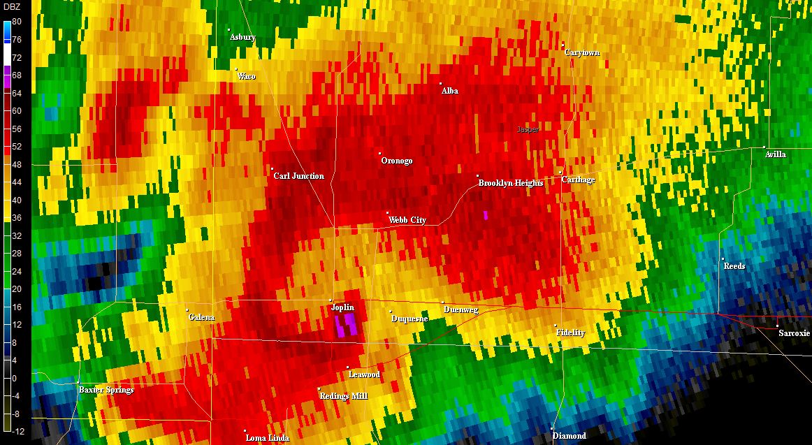
By 2042Z, the supercell is located near Smithville and likely near its peak intensity. A very tight concave reflectivity gradient is present in the inflow region of the supercell, a very impressive WER and BWER were also present, a hook echo persisted, and a very strong low and mid-level mesocyclone were still present.


A zoomed in image of the supercell west of Smithville (left) shows an impressive BWER at around 9,300 feet. As the supercell moved northeast of Smithville, a tornado signature can be seen in the storm relative motion data along with a very high normalized rotation (NROT) value typically only seen in intense mesocyclones and tornadoes.


By 2142Z, another cell had merged with the supercell and seemed to interfere with its structure. Nonetheless, a strong mesocyclone remained present along with a WER.


The supercell remains in tact another hour later, but it's clearly not as well-defined as it once was over Northeast Mississippi. It also becomes apparent that convection to its south may likely further disrupt the updraft.


Indeed, by 2343Z, the storm has weakened considerably and shows no signs of supercell characteristics.


By 00Z, the storm had pretty much dissipated but not before traveling a total of about 437 miles!

Damage Survey Images

Saturday, May 14, 2011

Scenes and Thoughts From Tuscaloosa

One of the worst tornado outbreaks in United States history occurred on Wednesday, April 27, 2011. 134 tornadoes have been confirmed (as of May 9) across 17 states with Alabama being the hardest hit. During a 24-hour period from 8 a.m. on April 27 to 8 a.m. on April 28, 309 people were killed, including 236 in Alabama.

Why did so many people die? I believe this article does an excellent job of providing many answers. Many folks in the meteorology community may disagree with me, but I don't think there's a lot to be learned from this event from a scientific meteorological perspective. It was extremely well forecast by the Storm Prediction Center and local Weather Forecast Offices up to five days in advance. However, I think there is a tremendous amount that we can and will learn about societal impacts from this tornado outbreak.

Arguably, the most recognizable tornado from this outbreak was the Tuscaloosa-Birmingham tornado. This tornado was rated an EF-4, it produced a continuous damage path for 80.3 miles, and it killed 65 people. It is the single deadliest tornado since May 25, 1955. Tuscaloosa was particularly hard hit where 41 fatalities occurred. A few days after the tornado, I traveled to Tuscaloosa to help out my mom and sister who were hit by the tornado and to get a firsthand view of the destruction. I witnessed the damage from the F4 tornado in Tuscaloosa on December 16, 2000, and I can attest that the magnitude and spatial extent of this damage was much worse.


The aerial image above shows the damage and devastation in the Forest Lake neighborhood associated with the April 27 tornado in Tuscaloosa. The numbers on the aerial image indicate where ground-level images were taken on April 30.


Image 1 was taken at 19th Street East and included a miracle story of survival. The house in the foreground was a single-level home with a basement. The house was completely destroyed with much of the rubble collapsing in the basement. The homeowner was an elderly woman that sought shelter in the basement, only to have her house collapse on top of her. After the tornado passed, a few students living across the street pulled the woman out of the wreckage. She sustained only minor injuries.


Image 2 is looking across Forest Lake at heavily damaged and destroyed homes along Forest Lake Drive where EF-4 damage occurred. Trees were also snapped, debarked, and thrown into the lake. Other debris in the lake included a refrigerator and a basketball goal.


Image 3 was taken near 1st Avenue and Fernwood Court. Part of a metal roof from University Place School was found twisted around a tree.

It's events like this that are the driving motivator of my career. Fortunately, I've never worked an event where lives have been lost, but I realize that won't be the case forever. However, after hearing the horror that my family went through and seeing many of my great childhood memories reduced to rubble, I have an even greater appreciation for my job as a warning forecaster.

Despite the circumstances in Tuscaloosa, I have complete confidence that the city will rebuild better than ever. I will be forever amazed at the amount of support and unity that I witnessed -- it was truly inspiring. If you feel compelled to help tornado victims, you can donate to the American Red Cross.